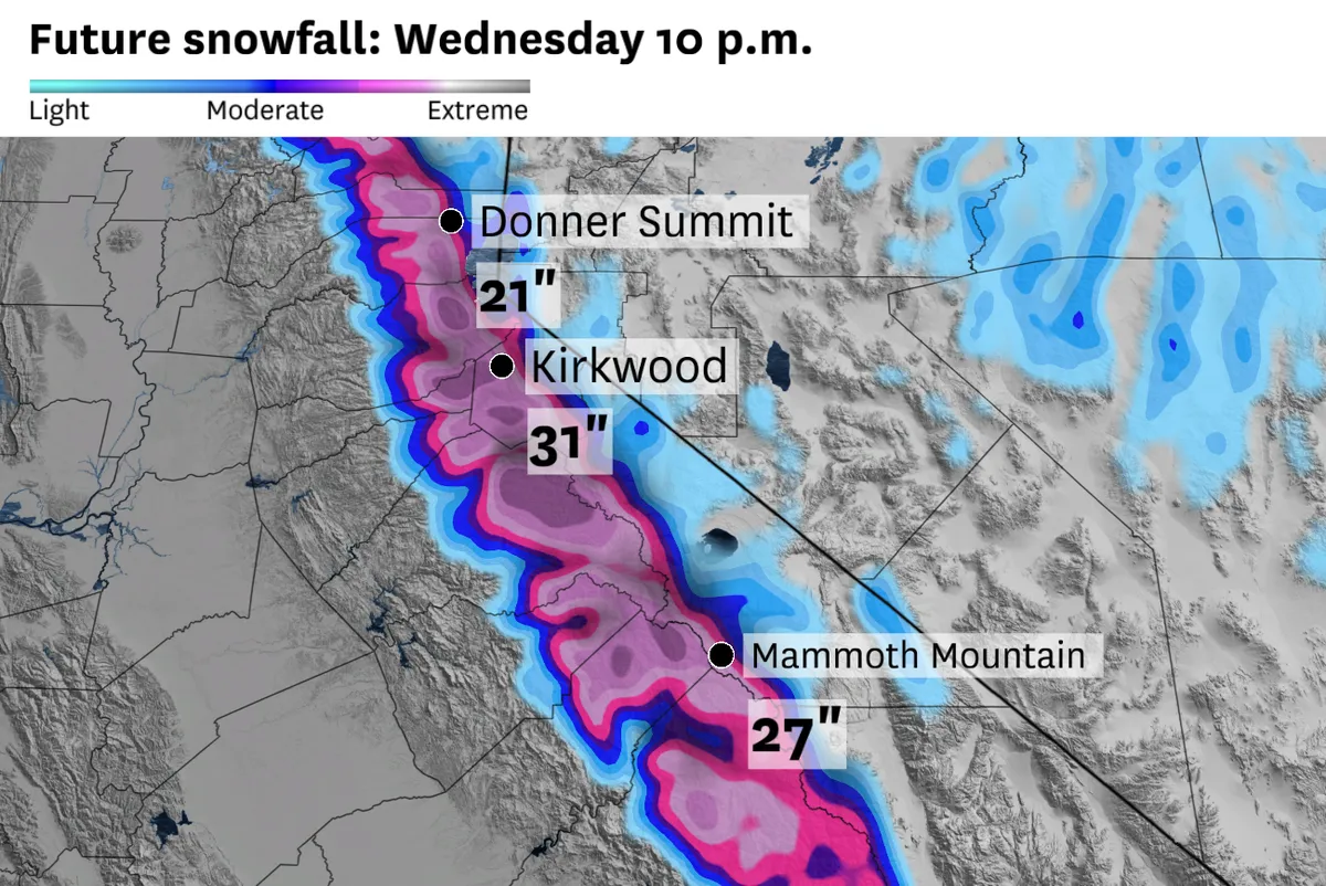
The Sierra Nevada region is currently under multiple winter storm warnings and advisories, with forecasts indicating that some areas could receive more than two feet of snow. This impending weather event, which is expected to peak on Tuesday afternoon and evening, could significantly disrupt travel due to snowfall rates reaching between one to two inches per hour.
According to documents from the National Weather Service, Interstate 80 and Highway 50 mountain passes are predicted to see over a foot of snow, while high-elevation ski resorts may experience up to three feet of accumulation. The warnings span a considerable distance—from Lassen National Park to Yosemite and Sequoia and Kings Canyon national parks—highlighting the extensive reach of this winter storm.
Travelers should prepare for challenging conditions; gusts of wind are anticipated to reach up to 50 mph at mountain passes and could even hit 90 mph atop ridges. Such conditions raise concerns about visibility and road safety in the affected areas.
The moisture trajectory associated with this storm originates from the south, a pattern that meteorologist Chris Smallcomb notes is typically not favorable for spillover precipitation east of the Sierra crest. This detail underscores the complexity of forecasting in such dynamic weather situations.
As this winter storm unfolds, it will mark the second such warning issued this month for the west slope of the Sierra—a noteworthy statistic considering it represents the most warnings issued in a single April since 2010 by the Sacramento weather service office.
In addition to snow, rain is also forecasted for Northern and Central California, with predictions suggesting between half an inch to four inches along various coastal slopes. This mixture of precipitation may further complicate conditions across the region.
While travel impacts are expected primarily on Tuesday, uncertainties remain regarding how severe these disruptions will be as conditions evolve. Furthermore, there are indications from sources that a couple of strong storms may even produce brief tornadoes in areas like the Sacramento Valley.
Details remain unconfirmed regarding specific timing and intensity but as conditions develop, both residents and travelers should remain vigilant. The situation continues to warrant close attention as meteorologists monitor changes in weather patterns.